
Shall I run back into the desert … and stay there until the devil has passed out of me and I am fit to meet human kind again without driving it to despair at the first look? I haven’t had enough desert yet ― Saul Bellow, Henderson the Rain King
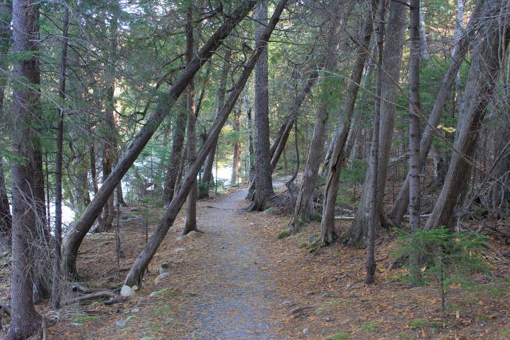
As I drove south through Sequoia on Generals Highway, heading to camp in the deep dark, I was thinking about how I don’t like to backtrack. But there are no roads over the Sierra Mountains unless you travel into Yosemite, which is five hours north and more than likely covered in snow. I would have to retrace through Bakersfield and then loop up the eastern side of the Sierras to get to Death Valley. A six hour drive. It was 8 PM and my plan was to spend the night in Sequoia and leave bright and early. Instead I passed the entrance to my campground and just kept driving.
It was 1 AM when I passed Valley Wells, California. The chocolate colored road was pin straight and grainy rough. In my brilliance, I had chosen a moonless night to travel through an unfamiliar, remote part of the country. A few feet on either side of the yellowed scrub that bordered the road, black draped the landscape. All was hidden to me except an illuminated twenty foot width of highway. I hadn’t seen another car in over an hour when a sign for Death Valley appeared in my high beams off to the right. A mile further, a brown sign read Panamint Springs. My lights lit the middle of the sign, while the edges strayed off in darkness. White arrows pointed to towns in either direction. Lone Pine, 50 miles west. Furnace Creek, 55 miles east. In the dead of night I had entered Death Valley at its center.
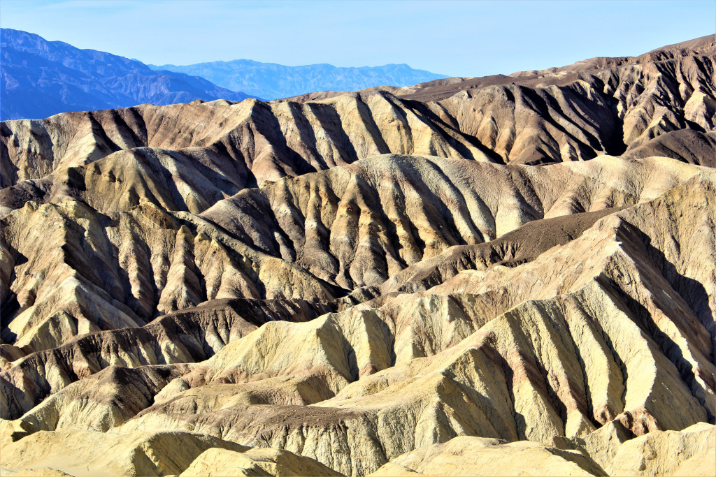
The vastness of Death Valley National Park can not be overstated. The largest park outside of Alaska, with over 3 million acres of designated wilderness, Death Valley is remarkably diverse. Bordered on either side by mountains reaching over 10,000 feet, she is a mixture of desert, peaks and canyons. In the spring, short-lived wildflowers attract hummingbirds, butterflies and bees. But her centerpiece is the desert floor. A landscape so unearthly in its appearance, yet diverse in its offerings, you are left with no frame of reference. One minute the desert is furrowed suede-like sand dunes, delicate windswept curves, never content to remain in one shape. The next, she is a great salt basin, with geometric designs, seemingly so precise you marvel at the artistry. Where she flows into foothills, she is craggy and rock strewn. Black, grey and laced with Pickleweed and Desert holly. In small places she gathers water left from the last ice age. In others, it flows through her, spilling from the narrow canyons, depositing ever changing colors and textures of sediment. She is beautiful in all forms.
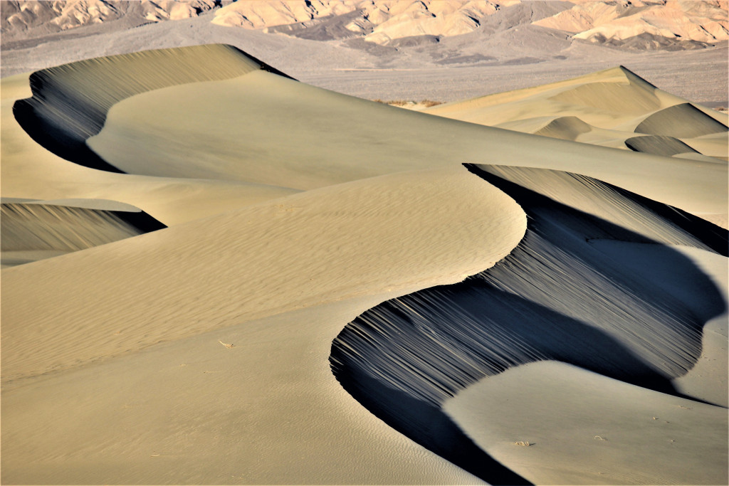
Mesquite Flat Sand Dunes. Lilting curves and shadowed detail. In the early morning, you can clearly see the tracks of animals and the swirling lines left behind by snakes.

Each time I walked on the dunes they presented themselves differently. Each time of day created a new set of shadows.
Golden Canyon trail-head leads into a series of twisting canyons, before opening to views of a red streaked, mineral laced 300 foot wall. As the narrow dirt trail climbs the ridge line, brown badlands sprawl to the north. Sitting one in front of the other, they disguise their mass, growing smaller with each upward step I take. Gaining one ridge line, the trail immediately leads up to another. The red wall is replaced by closer, black streaked sandstone. Drenched in sun, each detail of the rock is in precise detail. I hike along its base until the trail forks. To the right is a narrow ridge that appears to lead to the summit of a large group of boulders. To the left, the trail winds around the soaring yellow wall before disappearing up another climb. I followed the trail to the right, carefully making my way along the narrow plunging ridge. It’s a scramble to the top, but views of the canyons and multi-colored badlands below are beautiful. I sat for a while, as always listening to the wind, before turning around and picking up the trail.
I was beginning to wonder when I would start to descend. Several small dips in the trail, then another climb. Views of mustard colored hills and the Funeral Mountains to the east kept me company until I finally began to head down into the rocky dry and wide Gower Gulch. There are virtually no signposts on this hike. As the gulch gracefully winds through steep canyon walls, traces of past floods etched into the floor, I’m hoping my map reading skills have placed me in the right gulch. The one that should drop into the foothills in about two miles. The gulch is tilted toward the desert floor so the hiking is easy. Large boulders line the path, with others perched above waiting for a good shake before tumbling. The sound of my boots on the hard ground echo up the walls. Each turn brings either harsh sunlight or cool shade. It is late in the day and I welcome the sun as I round a corner. Several miles in the distance, across blackened foothills, Route 190 winds its way through the park. The undulating trail turns north and I am thirty minutes from trails end.
The mustard colored hills at the foot of Mustard Canyon.
Finding the road to Salt Creek closed due to the government shutdown, I parked and hiked the mile and a half in. I was in search of the elusive pupfish, a species that has evolved over thousands of years to be able to live in these extreme conditions. A wooden boardwalk leads through a marsh, winding across the creek several times. Pools gathered inside salt grasses. In other places the small creek flowed freely. I kneeled down at each pool to catch a glimpse of a pupfish. I had my long lens on my camera and wanted to digitally capture one. I waited. I waited. A couple approached me on bicycles. “Have you seen a pupfish?” Not a one. “They’ve become rather scare.” Have you seen one before? “Oh yeah. A few times. Less than an inch long. Kind of a bluish color. Well, good luck.” And away they rode, matching helmets bobbing up and down as they hit the end of the boardwalk. Again I waited. In the end there would be no pupfish today. Damn you pupfish.
I arrived at Badwater during the middle of a spectacular day. Pure blue. Not a single wisp of a cloud. People lined up to have their photo taken next to the wooden sign that read ‘Badwater Basin. 282 Feet / 855 Meters Below Sea Level’. Off to the right, a crystal clear pool of water held the blue reflection of the sky and the brown hills in the distance. Straight ahead, a disjointed line of people at varying distances, walking on the white salt basin that stretched for miles in three directions. I spotted the person furthest from the viewing platform and decided to walk to them and beyond. It’s a personality disorder.

A small pool at the edge of Badwater Basin.
When you first walk out into the salt basin, the earth is crumbled and broken. Deep brown clods of hard ground lay in jumbled random patterns, as if a field had been recently tilled and then frozen. As you walk further, everything begins to have a white edge. Salt crystals. Further still the earth begins to take on very precise shapes. Ridges of salt form geometric patterns. I’m about a mile out when I reach the last person. Actually, it’s a couple. Have you ever seen anything like this before? “Never.” How far do you think the mountains are from here? “Ten, fifteen miles. Why? You thinking about walking over there?” Yep. But then I would have to walk back. Laughter and then, “Best of luck.” Hey, do you want me to take a few photos of you guys. Shame to visit another planet and not have a shot of the two of you. “That would be great. Thank you.” Would you mind taking a shot of me as well? “You got it.” We took photos of each other and said our goodbye’s. They turned toward the platform and I continued across the basin.
As far as the floor stretches, ridges of salt create white rows, tinged with black earth that has seeped through and mingled. It is an landscape like no other. In front of me, 10,000 foot peaks of the Panamint Range protect the valley’s western flank. To the north and south, the valley lies unbroken as far as the eye can see.
I am alone in the middle of the Great Salt Basin. I am two miles from the platform as I reach down and pick up what looks like a snowball. An almost perfectly round orb of salt. I lick my finger, place it on the salt and taste. It had a strong, harsh flavor. I took several photographs, trying to capture the essence of a place so foreign. I also wanted to see if I could visually detail the actual crystals in the salt. For a while I just kept walking, amazed at where I found myself. Dazzled by the patterns. Then I thought I should lay down for a while. The salt felt coarse, like old snow that had re-frozen after a thaw. The sky was a single shade of blue. When I finally got up, the back of my clothes were wet from where the water, hovering just beneath the surface, seeped through the salt. As I walked back to the platform, I thought to myself that I should probably stop laying down in certain places.

The basin floor and its otherworldly shapes and textures. I would not recommend taking a nap here.

Salt crystals. Looks like salt. Tastes like salt.
Below Furnace Creek is Artists Drive. A nine mile one way drive, which leads you though a series of bluffs and canyons, until you arrive at Artists Palette. I had seen photos of Artists Palette, but until I stood directly in front of the jumbled ridges, I had always assumed that people were getting a bit overzealous with their altering of photos. “Add more color Dorothy. No more.” The sun was setting when I arrived, skimming the tops of the lumpy foothills. My immediate thought, as I stood and marveled at the range of colors in the volcanic ash, was that I couldn’t capture this in a photograph. Shades of orange, yellow, turquoise, violet, pink, greens and muted variations of each, mixed together to form an ineffable array of colors. I felt as if I was looking through a kaleidoscope, colors swirling at the twist of my hand. Mother nature showing off. I see you big MN. I see you.

Artists Palette. I visited twice trying to get the right light, but my timing was poor.
Natural Bridge is a short walk into a yellow ochre canyon. It stands beautifully poised, thousands of years in the making. A few people stood taking photos. I had come to see the bridge as well, but I wanted to explore the narrow canyons beyond the bridge. I would get my photos on the way out. As I hiked in, the walls became narrower. Still plenty of room, but tapering until you reach what looks like a dead end. I climb on a rock to see what is over the stack of boulders blocking my path. I looks like the canyon continues, so I put my camera in my backpack. I’m going to need my hands to scramble up and over. Twice after 100 yard intervals, the trail seems to dead end. Each time I managed to scramble up and over. Finally, I hit the end of what I knew was a box canyon. There it is. A 100 foot wall staring down at me, daring me to give it a go. Not a chance.
Turning and heading out of the canyon, the granite rocks that I had managed to climb, proved to be a bit more difficult to descend. At one point, the rocks were so smooth, there were no footholds. I tried to remember how I got up here. Didn’t matter. There was only one way down and that was to slide about twelve feet on my ass. I slowly sat down. I was hoping my head didn’t jerk back when I started. It was over in a second. My head went back but didn’t hit anything. My hands, instinctively reaching out, hit the rock and my baby finger bent at an angle not commonly found in nature. I let out a yelp and held my right hand in my left. This is not good Smitty. It didn’t really hurt. It just looked funny. For a moment I thought about just letting it be. It would match my nose. Instead I gave it a hard twist. The sound was ugly, like a large knuckle popping. But the angle looked right and I could move it. No big deal I thought, as I walked out. When the throbbing set in I wasn’t so cavalier. Several weeks later it’s almost as good as new, with only the occasional ache and a funny little pop when I twist it. Hey, who doesn’t want a bumpy knuckle? Adds character as my dad used to say.

Natural Bridge. A good precursor to what I am going to see on a much grander scale in Arches NP.
Dante’s View is a testament to the determination of park engineers. A thirteen mile spur off Route 190, the road begins near sea level and tops out at 5,475 feet. There are length restrictions on vehicles due to the winding nature of the road. At several points the grade is 10% and the higher you climb the steeper the incline. It’s listed on dangerousroads.org. When you arrive, the panoramic view of the valley below is staggering. To the south, the Owlshead Mountains. To the north, the Funeral Mountains are visible beyond Furnace Creek over thirty miles away. To the west, across Badwater Basin, the Panamint Range rises dramatically to Telescope Peak. To the east the Greenwater Range. And on this early clear evening, the 14,505 foot tip of Mt. Whitney, the tallest peak in the lower 48.
The solid halite salt of Devil’s Golf Course appears as an ocean, with great tributaries bringing life to the desert. Route 190 looks like a single black thread. Where the salt disappears, the basin fades from brown, to grey, then black. As I scramble up and over sharp black rocks to the brink of the edge, high above the viewing area, I have the sensation of looking at a landscape from miles above the earth. I am awestruck by the display laid out in front of me. I am hovering in space. The wind is howling and the temperature is 25 degrees cooler than where I was standing an hour ago. I’m freezing, but I can’t move. I am dumbstruck by nature’s majesty.

Badwater Basin from 5,475 feet. I was so cold and shaking, I’m surprised any of the photos came out.
Every time I look at this shot, I feel like I’m circling the earth and this is a great sprawling river on the African continent.

I’m glad anyone who cares about me – both of you know who you are – can’t see where I was standing when I took this.
My last night in the park, I sat beneath the freckled stars late into the night. Death Valley harbors some of the darkest night skies in the United States. Certified as the third International Dark Sky Park in the U.S. National Park System, the complete lack of ambient light allows the stars to shine like few places on earth. As my eyes adjusted and the seemingly bleached stars took shape, I began to think of Death Valley as a place of many canvases, blessed with an unmatched palette. Each one a singular portrait, distinct, yet enhancing the other. I thought of the scale and breadth of artistry demanded by this canvas. The versatility required to perform a marriage of disparate heights and textures. As my eyes grew heavy, I began to trace familiar constellations. I thought of the first time I pitched a tent in the back yard of my parents small home on Gardenia and read The Nick Adams Stories over and over. As I fell asleep, stars blinked their good night and I knew I had witnessed perfection.

This is Edith. She is the girl with the faraway look in her eye.

Looking north across the desert floor at sunset. It’s impossible to get a sense of scale from the floor. 10,000 foot mountains appear as small lumps. My head even looked small out here.
I found this fellow in the town of Lone Pine, just west of Death Valley. He asked me for a quarter. When I told him I saved my quarters for laundry, he looked at me out of the corner of his eye and said, “Scram.”

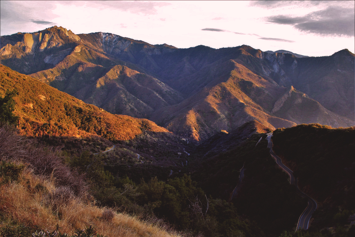
I love how the black ribbon roads follow contours of the landscape.

The entirely out of context Inn at Furnace Creek. Rooms are $465 on Trivago. I thought about it, but decided I would rather eat during the month of January.

Just north of Lone Pine is Manzanar Internment Camp where thousands of Japanese Americans were held during WWII. It is a sacred place. You can only imagine the depth of sadness witnessed here.

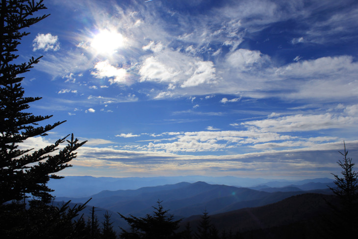
I camped on the remote outskirts of Lone Pine a few days so I could write before heading back into Death Valley. I woke up to this sky one morning.

Another morning sky outside Lone Pine. For those of who are familiar with Harry Potter, I was certain the Death Eaters were coming to get me. I hid until noon.

My hiking partner, Murray. He made me promise to email a copy of all the photos I took of him. CoolBreezeMurray@Hotmail.com
NOTE: For more information on Death Valley National Park and all the National Parks and to help with trip planning, download the free Chimani app to your smart phone to easily navigate your way around the park, with or without cell phone service.